
A Stanford University study warns that coastal highways face a growing risk of flooding from sea level rise and storm surges that cascade into delays for commuters with limited road alternatives that may be miles away from flooding.
Growing delays for commuters getting to work are bound to spill over to the delivery of goods through ports, warehouses and manufacturers.
Otherwise, more extreme weather conditions could paralyze road transportation.
The study entitled “When floods hit the road: Resilience to flood-related traffic disruption in the San Francisco Bay Area and beyond” states:
“As sea level rises, urban traffic networks in low-lying coastal areas face increasing risks of flood disruptions. Closure of flooded roads causes employee absences and delays, creating cascading impacts to communities. We integrate a traffic model with flood maps that represent potential combinations of storm surges, tides, seasonal cycles, interannual anomalies driven by large-scale climate variability such as the El Niño Southern Oscillation, and sea level rise.”
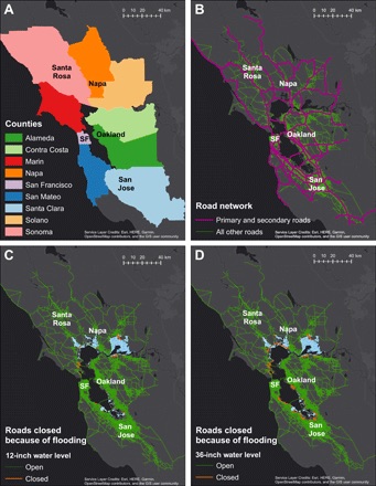
Co-author Indraneel Kasmalkar, a PhD candidate at the Institute for Computational and Mathematical Engineering at Stanford, cited flooding threats at the San Francisco Bay Bridge and two other Cross-Bay Bridges, “which could suffer shut downs if the approaches to the bridges become flooded.” He also cited the case of California State Route 37 linking Marin, Solano and Napa counties in the North end of the San Francisco Bay. SR 37 was temporarily shut down in 2019 due to flooding. Within 20 years the effects of global warming and sea level rise could result in the highway being flooded multiple times per year, researchers believe.

Elevating SR 37 is proposed to keep the roadway flood free, but could cost California billions of dollars to construct: “The problem is that if the road approaches to SR37 become flooded, then elevating SR 37 will not work.” Kasmalkar noted.
He explained: “While our model identifies flooded roads based on the flood maps, our research does not really say much about specific interventions to reduce flood-related traffic disruption. Our research highlights important metrics that we should keep in mind when designing transportation networks, like road network density, regional jobs-housing imbalances, and, to some extent, flood exposure. But to understand the value of an intervention, like elevating a road, or adding roads in a particular region, we would have to do follow-up research involving simulations with those options.”
Another report co-author, Jenny Suckale, assistant professor, Geophysics and Center Fellow, Stanford Woods Institute for the Environment told AJOT that a combination of worsening storm surges, flooding, sea level rise and the growing incidence of fires in Northern California is going to require a radical upgrade in the transportation systems of coastal communities not only in Northern California but for coastal communities everywhere: “The dams, levees and transportation systems in Northern California were built decades ago and are not designed to take the stresses of additional flooding and storm surges.”

It is possible, transportation planners might seek to avoid the massive cost of rebuilding coastal roads by moving more cars and trucks by water and by ferries. Ferries were a main mode of transportation before the construction of bridges and highways in the 1930s.
Suckale, also a member, Institute for Computational and Mathematical Engineering (ICME), says computational research had focused on global sea level rise and not on the more immediate local threats that are evident in 2020 from hurricanes, flooding and storm surges:
“You can’t build a new high-speed computer and expect it to solve the problem… research needs to be more purpose driven and more focused on annual trends. Our research and software needs to be more focused on here and now.”
Suckale credits U.S. Geological Survey (USGS) advances in coastal impact research for helping focus the Stanford study.
In 2019, AJOT reported that Patrick Barnard, research geologist, U.S. Geological Survey, led a team that produced a USGS report that projects a “likely” 0.25 meter or 9.8-inch sea level rise by the year 2040. The impact to California factoring “an extreme storm … would cause substantial flooding that would directly affect over 150,000 residents and $30 billion in property damage.”
Juliette Finzi Hart, an oceanographer with USGS, added: “The (USGS) report incorporates new science that provides us with better projections because historical data is not as relevant when sea levels are rising. In California, wave energy adds to storm surge as well as sea level rise to create a stronger effect on coastal communities… This is happening sooner than expected… In California, emergency services agencies are pretty savvy on the threats posed by sea level rise…”
The Coastal Storm Modeling System (CSMS) used for the projections in the USGS report “was designed to thoroughly assess future coastal flooding exposure by integrating SLR (sea level rise), dynamic water levels and coastal change.” Hart said CSMS “can be used by planning, emergency services and insurance companies to make risk assessments for new and existing cities, ports, airports, highways, rail lines, bridges and levees. Local, state and federal emergency services agencies need to upgrade their planning to take into account intensifying damage from sea level rise beginning in 2040 and not 2100.
Suckale echoes this analysis: planning and new construction for roads, ports, bridges, dams and new transportation systems need to be accelerated. “The historical approach to sea level rise was that the threat was going to happen at the end of the century. It’s not. It’s happening right now.”
